Within Virginia
Why Does Virginia Produce So Many UFO Reports?
Airports, naval ranges, shipping routes and military installations create both unusual observations and difficult identification problems.
On this page
- Airports, naval bases and Atlantic training areas
- How ordinary lights become difficult to identify
- The evidence needed to separate mystery from misidentification
Page outline Jump by section
Introduction
Virginia produces many UFO reports because it places large numbers of observers, aircraft and sensors in one of America’s most complicated aerial environments. Northern Virginia lies beneath the crowded Washington flight system, while Hampton Roads combines civilian airports, naval aviation, helicopter traffic, drones, warships and offshore training ranges. People are therefore more likely to see something unfamiliar—and less likely to have all the information needed to identify it.
That combination matters more than the raw number of sightings. A distant aircraft turning towards an observer can appear stationary; several jets approaching in sequence can resemble lights in formation; a balloon or drone may be detected without useful range data; and activity inside a military exercise area may not be publicly explained. Some Virginia reports remain genuinely unresolved, particularly when trained crews describe repeated encounters. Yet “unresolved” often means that the observation was too brief or poorly recorded to test, not that extraordinary technology has been demonstrated.[vipc.org]vipc.orgHampton Roads Airspace AnalysisHampton Roads Airspace Analysis7 Dec 2023 — Special Use Airspace & Other Special Conditions including 267 airports, The state also co…
Airports, bases and training areas crowd the sky
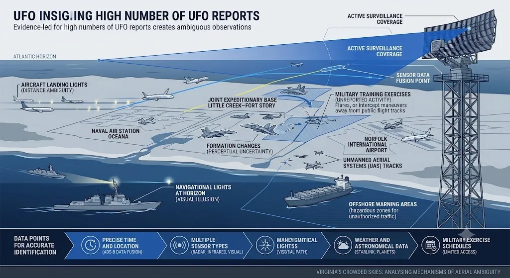
Virginia does not have one single UFO hotspot. It has several overlapping aviation systems that create different kinds of ambiguous observation.
In the north, Washington Dulles International Airport and Ronald Reagan Washington National Airport both physically lie in Virginia. In 2024, each handled roughly 13 million departing passengers, placing them among the country’s busiest commercial airports. Their traffic is managed alongside flights using Baltimore–Washington International Airport, Joint Base Andrews and numerous government helicopter routes. The Federal Aviation Administration’s Potomac Terminal Radar Approach Control facility coordinates aircraft arriving at and departing from the region’s three principal commercial airports, illustrating how traffic that appears separate from the ground forms one connected aerial network.[Federal Aviation Administration]faa.govarp cy2024 commercial service enplanementsarp cy2024 commercial service enplanements
The Washington area also contains an unusual amount of low-level government aviation. Before restrictions imposed after the fatal January 2025 collision near Reagan National Airport, 28 agencies were authorised to use helicopter routes around the airport. Users included the armed forces, police, emergency services and other federal bodies. Some military aircraft can operate without publicly transmitting Automatic Dependent Surveillance–Broadcast, or ADS-B, position data when mission requirements justify it. Consequently, a witness using a public flight-tracking application may see an aircraft in the sky but no corresponding icon on the screen. That mismatch can make an ordinary government flight appear more mysterious than it is.[Reuters]reuters.comCantwell questioned the logic of having military training flights so close to civilian flight corridors. The collision involved a U.S. Ar…
Southeastern Virginia presents a different form of congestion. Norfolk International Airport and several smaller civilian airfields operate near Naval Station Norfolk, Joint Base Langley–Eustis, Naval Air Station Oceana, Joint Expeditionary Base Little Creek–Fort Story and other defence facilities. A state-backed analysis identified 267 airports and landing facilities across Virginia, including 11 military airports, and described Hampton Roads as an area where civilian, military and special-use airspace must be carefully integrated.[VIPC]vipc.orgHampton Roads Airspace AnalysisHampton Roads Airspace Analysis7 Dec 2023 — Special Use Airspace & Other Special Conditions including 267 airports, The state also co…
Naval Air Station Oceana is especially important to Virginia’s modern UFO history. The base supports Atlantic Fleet strike-fighter operations and is home to 17 aviation squadrons, most flying F/A-18 Super Hornets. Its crews train locally and in offshore operating areas, sometimes conducting air-combat manoeuvres or weapons exercises unlike the predictable, straight-line movement of an airliner. The Navy also operates a small-unmanned-aircraft training facility at Little Creek–Fort Story. In other words, the Virginia Beach region contains both fast military jets and comparatively small drones, two categories frequently implicated in difficult aerial identifications.[CNRMA]cnrma.cnic.navy.milOpen source on navy.mil.
Beyond the coastline lie warning areas: designated zones in which military activity may be hazardous to aircraft not taking part. These areas extend over coastal and international waters and allow training that would be difficult to conduct over populated land. An observer on Virginia Beach, a sailor offshore or a pilot crossing the region may therefore witness flares, formation changes, intercept exercises, drones or aircraft seen from unfamiliar angles. The observer may know that something was present but lack access to exercise schedules or the tracks of participating aircraft.[Federal Aviation Administration]faa.govOpen source on faa.gov.

Why ordinary lights become difficult to identify
Busy airspace increases the number of potential UFO reports, but geometry and perception determine what those reports look like. At night, a bright point often provides no reliable indication of its distance, size or speed. A light five miles away and a brighter light fifty miles away can occupy a similar apparent position in the sky.
Aircraft landing lights are a common example. A jet approaching almost directly towards a witness may appear to hover because its sideways movement is too small to notice. When it turns, the light may suddenly dim, vanish or seem to accelerate. Several aircraft following the same arrival route can form a line or triangle, particularly when their navigation lights are visible but their bodies are lost against the dark sky.
Movement by the observer complicates matters further. From a car, ship or aircraft, a distant object can appear to move because nearby reference points are shifting. In aviation imagery, parallax—the apparent displacement produced by the motion of the observing platform—can exaggerate the apparent speed of a distant object. Camera glare, automatic focus, digital zoom and infrared processing may also distort an object’s shape. NASA’s independent UAP study warned that many existing reports lack calibrated sensor information, precise locations, range measurements or standardised metadata, making confident conclusions difficult even when an image looks striking.[NASA Science]science.nasa.govNASA ScienceIndependent Study Team ReportThe study of Unidentified Anomalous Phenomena (UAP) presents a unique scientific opportunity tha…
Pilots are better trained than most witnesses, but training does not make human vision an infallible measuring instrument. Aviation safety material notes that lights on the ground can be mistaken for stars or a horizon at night, especially over dark or featureless terrain. Over the Atlantic east of Virginia, there may be few visual references besides scattered ship, aircraft and celestial lights. A pilot can give an accurate account of what appeared unusual while still being unable to establish the object’s true distance or motion.[NTSB Data]data.ntsb.govData Other Pertinent Forms and ReportsData Other Pertinent Forms and Reports
Satellites have added another source of confusion. Newly deployed Starlink spacecraft can appear as lines or clusters, while individual satellites may brighten unexpectedly as sunlight reflects from them. A 2024 aviation study reconstructed a case in which five airline pilots on two flights reported unusual objects; satellite orbital data and aircraft tracks indicated that recently launched Starlink satellites, seen under unusual illumination, explained the observations. The case did not occur in Virginia, but the mechanism applies directly to pilots and residents looking over Virginia’s dark Atlantic horizon. Multiple credible witnesses can independently report the same real light while being mistaken about what produced it.[arXiv]arxiv.orgOpen source on arxiv.org.
Coastal weather creates further uncertainty. Haze, thin cloud and humid air can enlarge or diffuse lights, while cloud layers may hide an aircraft’s structure and leave only intermittent illumination. Searchlights, rocket exhaust, atmospheric research flights and high-altitude aircraft can become visible over a wide area. In June 2024, for example, NASA warned residents that low-flying research aircraft would be operating over Richmond and southeastern Virginia to measure air pollution—exactly the sort of unusual but legitimate activity that might otherwise prompt local speculation.[WHRO Public Media]whro.orgPublic Media See a NASA plane flying around Hampton Roads? Here'sPublic Media See a NASA plane flying around Hampton Roads? Here's
Shipping routes add lights that are easily misjudged from beaches and aircraft. A ship’s position near the horizon is difficult to estimate without a clear shoreline reference, and lights on vessels can seem suspended above the water when the hull is hidden by darkness, haze or the curvature of the sea. Ships may also support helicopters, drones or exercises associated with the Norfolk naval complex. None of these possibilities automatically explains a particular sighting, but they enlarge the number of ordinary candidates investigators must eliminate.
Why military areas generate both reports and uncertainty
Military aviation produces more than unfamiliar objects. It also produces unusually capable observers. Fighter crews have good reasons to notice unexpected traffic: an untracked balloon, drone or aircraft may pose a collision hazard, interfere with training or indicate surveillance of a sensitive area. Improved reporting procedures can therefore increase the recorded number of UAP encounters even when the underlying number of unusual objects has not changed.
This helps explain the prominence of reports from Navy aviators operating off Virginia Beach after 2014. Pilots described objects appearing repeatedly in training airspace used by aircraft from Oceana. The location is significant because crews returned to the same operating areas with advanced radar and infrared equipment, creating repeated opportunities to detect objects that civilian witnesses would never see. It is also a setting in which balloons, small drones, distant aircraft, sensor artefacts and genuinely unrecognised traffic all have security implications. The encounters deserve investigation because of flight safety and airspace control, but their occurrence near a military range does not by itself establish extraordinary performance.[navy.mil]cnrma.cnic.navy.milOpen source on navy.mil.
Secrecy can preserve uncertainty. Officials may be unable to discuss a classified platform, electronic-warfare test or operational procedure. Conversely, investigators may suspect a foreign surveillance device but lack enough evidence to attribute it publicly. A report can therefore remain “unidentified” for administrative or evidential reasons even when no exotic explanation is required.
The problem is not merely hypothetical. Public concern over drones near Virginia installations intensified in 2024. Naval Air Station Oceana acknowledged reports of possible drone activity in the area but said it had detected nothing unusual or unscheduled at the time. That distinction is important: public reports can multiply rapidly around a sensitive base, while checks by the installation produce a less dramatic assessment. Some observations may involve legitimate aircraft, stars, drones operating elsewhere or repeated reports of the same object.[13newsnow.com]13newsnow.comOpen source on 13newsnow.com.
Military secrecy can also encourage an opposite error: assuming that every unexplained light must be a secret test. A restricted range is not an identification. Unless records show that a particular exercise, aircraft or drone occupied the relevant place at the relevant time, “probably military” remains a plausible hypothesis rather than a demonstrated solution.
More traffic means more reports, not necessarily more anomalies
Virginia’s aviation environment raises UFO-report numbers through a simple exposure effect. More aircraft produce more lights. More pilots and radar systems produce more observations. More military exercises produce more unusual manoeuvres. More sensitive installations create stronger incentives to report anything that does not belong. The same environment also produces duplicated observations, because many people can see one launch, exercise or line of approaching aircraft.
Official UAP findings support caution about interpreting raw report totals. The Pentagon’s All-domain Anomaly Resolution Office, known as AARO, lists balloons and satellites as the largest categories among reports for which a likely identity has been recorded; birds, aircraft, drones and sensor artefacts also appear. Its 2024 report said that 118 cases resolved during the reporting period were attributed to ordinary objects such as balloons, birds and unmanned aircraft. Many other cases remained open principally because the available information was insufficient for a confident judgement.[aaro.mil]aaro.milOpen source on aaro.mil.
That pattern does not show that every Virginia UFO was misidentified. It shows why a high number of reports cannot be treated as a count of extraordinary craft. A region with dense aviation and active surveillance should be expected to generate both more solved cases and more unresolved cases than a region with little traffic. Poor data and unusual objects rise together.
Nor should an unresolved file be treated as a permanent mystery. Some cases weaken when flight tracks, satellite positions, weather information or better sensor analysis become available. Others remain unresolved because those records were never collected or were not retained. The meaningful question is therefore not simply whether officials assigned a name to an object, but whether the report contains enough information to test its claimed behaviour.
What evidence can separate mystery from misidentification?
A useful Virginia investigation has to reconstruct the airspace rather than judge a witness’s description in isolation. Testimony matters, particularly when recorded promptly, but it becomes much stronger when joined to independent measurements.
The most valuable evidence includes:
- Exact time and location. Even a discrepancy of several minutes can change which aircraft, satellite or launch was visible.
- Direction and elevation. “Over the base” is often an impression rather than a measured position. A compass bearing and angle above the horizon greatly narrow the possibilities.
- Duration and continuous observation. A light seen continuously for five minutes is easier to analyse than one noticed intermittently through trees or cloud.
- Original files. Investigators need the unedited photograph or video, including metadata, rather than a compressed social-media copy.
- Aircraft and exercise records. Civilian radar and ADS-B data can identify many flights, but military aircraft may be absent or partially represented.
- Weather and astronomical data. Cloud height, wind direction, visibility, planets, meteors and satellite passes can provide direct tests.
- Multiple separated viewpoints. Observers at different known locations allow triangulation—the calculation of an object’s position from sightlines.
- Sensor context. Radar or infrared detections are most useful when the equipment mode, range, calibration and tracking history are preserved.
NASA’s UAP study argued that serious analysis requires standardised, well-calibrated and multi-sensor data. Experimental research projects have reached the same broad conclusion, proposing combinations of wide-field cameras, radar, radio receivers, acoustic instruments and environmental sensors. The purpose is not simply to gather more footage, but to measure distance, trajectory and physical characteristics while recognising reflections, glare and equipment artefacts.[NASA Science]science.nasa.govNASA ScienceIndependent Study Team ReportThe study of Unidentified Anomalous Phenomena (UAP) presents a unique scientific opportunity tha…
This standard explains why many dramatic accounts cannot be settled. A witness may accurately remember a light making an apparently impossible turn, yet without range information the calculation of speed is speculative. A radar return may be real, but without data about the radar mode and surrounding tracks it may represent clutter or an ordinary target. A video may depict a genuine object while giving no reliable clue to its size.

What Virginia’s busy sky really tells us
Virginia’s UFO record is not simply the product of credulous witnesses, nor is its concentration around military facilities proof that extraordinary vehicles are monitoring them. The state is a natural reporting zone because it combines crowded commercial corridors, low-level government flights, fighter bases, offshore warning areas, drones, shipping activity and large numbers of trained observers.
Those conditions create a double effect. They expose people to aircraft and lights that are difficult to recognise, while also increasing the chance that a genuinely unauthorised or unusual object will be detected. That is why the best Virginia cases should be treated as airspace-investigation problems first. Some will resolve into aircraft, balloons, satellites or drones. Some may remain open because crucial data are missing. A smaller number may retain genuinely puzzling features, but they become significant only when those features survive comparison with the ordinary complexity of Virginia’s sky.
Amazon book picks
Further Reading
Books and field guides related to Why Does Virginia Produce So Many UFO Reports?. Use these as the next step if you want deeper reading beyond the article.
The UFO Experience: A Scientific Inquiry
Explains classification and investigation of sightings.
The Report on Unidentified Flying Objects
Provides background on military and civilian reports.
UFOs: Generals, Pilots, and Government Officials Go on the Re...
Strong fit for aviation-related UFO reports.
The Demon-Haunted World: Science as a Candle in the Dark
Rating: 4.5/5 from 43 Google Books ratings
Encourages evidence-based interpretation of unusual observations.
eBay marketplace picks
Marketplace Samples
Live-tested eBay searches with available results related to this page.
Selected fromaviation poster oneBay.co.uk.




Endnotes
1.
Source: vipc.org
Title: Hampton Roads Airspace Analysis
Link:https://vipc.org/wp-content/uploads/Hampton-Roads-Airspace-Analysis-.pdf
Source snippet
Hampton Roads Airspace Analysis7 Dec 2023 — Special Use Airspace & Other Special Conditions including 267 airports, The state also co...
2.
Source: science.nasa.gov
Link:https://science.nasa.gov/wp-content/uploads/2023/09/uap-independent-study-team-final-report.pdf
Source snippet
NASA ScienceIndependent Study Team ReportThe study of Unidentified Anomalous Phenomena (UAP) presents a unique scientific opportunity tha...
3.
Source: reuters.com
Link:https://www.reuters.com/world/us/senator-questions-military-helicopter-flights-near-civilian-airplanes-dc-2025-01-31/
Source snippet
Cantwell questioned the logic of having military training flights so close to civilian flight corridors. The collision involved a U.S. Ar...
4.
Source: cnrma.cnic.navy.mil
Link:https://cnrma.cnic.navy.mil/installations/NAS-Oceana/
5.
Source: navy.mil
Link:https://www.navy.mil/Press-Office/News-Stories/display-news/Article/3178188/first-small-unmanned-aircraft-systems-training-facility-opens/
6.
Source: science.nasa.gov
Link:https://science.nasa.gov/uap/
7.
Source: data.ntsb.gov
Title: Data Other Pertinent Forms and Reports
Link:https://data.ntsb.gov/Docket/Document/docBLOB?FileExtension=.PDF&FileName=Other+Pertinent+Forms+and+Reports+-+Spatial+Disorientation+Reference+Material-Master.PDF&ID=40075592
8.
Source: data.ntsb.gov
Link:https://data.ntsb.gov/carol-repgen/api/Aviation/ReportMain/GenerateFactualReport/91981/pdf
9.
Source: arxiv.org
Link:https://arxiv.org/abs/2403.08155
10.
Source: whro.org
Title: Public Media See a NASA plane flying around Hampton Roads? Here’s
Link:https://www.whro.org/environment/2024-06-21/see-a-nasa-plane-flying-around-hampton-roads-heres-why
11.
Source: twz.com
Link:https://www.twz.com/33371/here-are-the-detailed-ufo-incident-reports-from-navy-pilots-flying-off-the-east-coast
12.
Source: secnav.navy.mil
Title: Office of the Secretary of the Navy FY22 FOIA Log__Red Box_Redacted
Link:https://www.secnav.navy.mil/foia/readingroom/CaseFiles/FOIA%20Logs/FY22%20FOIA%20Log__Red%20Box_Redacted.pdf
13.
Source: 13newsnow.com
Link:https://www.13newsnow.com/article/news/national/military-news/drone-sightings-at-naval-air-station-oceana/291-af6b3476-ba37-4ced-a61c-f6f2163b0507
14.
Source: aaro.mil
Link:https://www.aaro.mil/UAP-Cases/UAP-Reporting-Trends/
15.
Source: arxiv.org
Link:https://arxiv.org/abs/2305.18566
16.
Source: aaro.mil
Title: AAR O Congressional/Press Products
Link:https://www.aaro.mil/Congressional-Press-Products/
17.
Source: aaro.mil
Title: AAR O Congressional/Press Products
Link:https://www.aaro.mil/Congressional-Press-Products/%5D/
18.
Source: aaro.mil
Title: AAR O UAP Trends
Link:https://www.aaro.mil/UAP-Cases/UAP-Reporting-Trends/quot/
19.
Source: netc.navy.mil
Link:https://www.netc.navy.mil/Media-Center/News-Stories/News-Stories-Display/Article/3949588/censecfor-pilots-bsco-phase-ii/
20.
Source: ntsb.gov
Link:https://www.ntsb.gov/investigations/Pages/WPR23MA113.aspx
21.
Source: netc.navy.mil
Title: mil Surface Combat Systems Training Command: Contact Us
Link:https://www.netc.navy.mil/Commands/Surface-Combat-Systems-Training-Command/SCSTC-Hampton-Roads/Contact-Us/
22.
Source: ntsb.gov
Link:https://www.ntsb.gov/news/press-releases/Pages/NR20210209.aspx
23.
Source: ntsb.gov
Link:https://www.ntsb.gov/news/press-releases/Pages/NR20200714.aspx
24.
Source: ntsb.gov
Link:https://www.ntsb.gov/investigations/Pages/DCA20MA059.aspx
25.
Source: navy.mil
Link:https://www.navy.mil/Press-Office/News-Stories/display-news/Article/2249866/iwtc-virginia-beach-offers-completes-new-pilot-course-for-ctrs/
26.
Source: navy.mil
Link:https://www.navy.mil/Press-Office/Press-Releases/display-pressreleases/Article/2246793/newest-iwc-officers-graduate-iwtc-virginia-beachs-modernized-pilot-course/
27.
Source: navy.mil
Link:https://www.navy.mil/Press-Office/News-Stories/display-news/Article/2254911/iwtc-virginia-beach-graduates-ip-basic-course-pilot/
28.
Source: doncio.navy.mil
Title: mil Department of Navy Chief Information Officer Mobile
Link:https://www.doncio.navy.mil/Mobile/ContentView.aspx?ID=8666&TypeID=21
29.
Source: navy.mil
Link:https://www.navy.mil/Press-Office/Press-Releases/display-pressreleases/Article/2263360/navys-first-information-dominance-basic-course-idbc-graduates/
30.
Source: doncio.navy.mil
Title: Article Details.aspx
Link:https://www.doncio.navy.mil/%28cggu5urfrjgcrguzbuqo0pr3%29/CHIPS/ArticleDetails.aspx?ID=6090
31.
Source: doncio.navy.mil
Title: mil CHIP S Articles: Aegis Ashore Team Trainer Facility Opens
Link:https://www.doncio.navy.mil/chips/ArticleDetails.aspx?ID=5727
32.
Source: ntsb.gov
Link:https://www.ntsb.gov/investigations/pages/ANC13GA036.aspx
33.
Source: ntsb.gov
Link:https://www.ntsb.gov/Pages/brief.aspx?ev_id=33438&key=0
34.
Source: ntsb.gov
Link:https://www.ntsb.gov/Pages/brief.aspx?ev_id=51630&key=0
35.
Source: ntsb.gov
Link:https://www.ntsb.gov/Pages/brief.aspx?ev_id=37218&key=0
36.
Source: ntsb.gov
Link:https://www.ntsb.gov/Pages/brief.aspx?ev_id=84755&key=0
37.
Source: ntsb.gov
Link:https://www.ntsb.gov/Pages/brief.aspx?ev_id=63140&key=0
38.
Source: ntsb.gov
Link:https://www.ntsb.gov/Pages/brief.aspx?ev_id=745&key=0
39.
Source: aaro.mil
Link:https://www.aaro.mil/Next-AARO-Home-redesign/Next-Parent/Next-UAP-Report-Documents/
40.
Source: aaro.mil
Link:https://www.aaro.mil/Next-AARO-Home-redesign/Next-Parent/Next-AARO-UAP-Imagery-Acc-Table/
41.
Source: aaro.mil
Link:https://www.aaro.mil/Next-AARO-Home-redesign/Next-Parent/Next-AARO-UAP-Imagery-Fixed-Table/
42.
Source: aaro.mil
Link:https://www.aaro.mil/UAP-Cases/Official-UAP-Imagery/4/
43.
Source: aaro.mil
Title: UAP Imagery UAP Video
Link:https://www.aaro.mil/Next-AARO-Home-redesign/Inactive-Parent/Next-UAP-Imagery-dup/
44.
Source: aaro.mil
Link:https://www.aaro.mil/Next-AARO-Home-redesign/Inactive-Parent/Next-Congressional-Press-Products/
45.
Source: aaro.mil
Link:https://www.aaro.mil/
46.
Source: aaro.mil
Link:https://www.aaro.mil/FAQ/
47.
Source: aaro.mil
Link:https://www.aaro.mil/UAP-Cases/Official-UAP-Imagery/
48.
Source: netc.navy.mil
Title: mil Center for Naval Aviation Technical Training Unit Oceana: Home
Link:https://www.netc.navy.mil/CNATTOceana/
49.
Source: netc.navy.mil
Title: mil Center for Naval Aviation Technical Training Unit Oceana:Contact Us
Link:https://www.netc.navy.mil/Commands/Center-for-Naval-Aviation-Technical-Training/Oceana/Contact-Us/
50.
Source: secnav.navy.mil
Title: mil F Y24 FOIA Log_Red Box_Redacted
Link:https://www.secnav.navy.mil/foia/readingroom/CaseFiles/FOIA%20Logs/FY24%20FOIA%20Log_Red%20Box_Redacted.pdf
51.
Source: secnav.navy.mil
Title: mil F Y 23 FOIA Log
Link:https://www.secnav.navy.mil/foia/readingroom/CaseFiles/FOIA%20Logs/FY%2023%20FOIA%20Log_Redacted.pdf
52.
Source: science.nasa.gov
Link:https://science.nasa.gov/uap/faqs/
53.
Source: 13newsnow.com
Link:https://www.13newsnow.com/article/news/local/mycity/virginia-beach/mysterious-light-brightens-the-sky-over-hampton-roads/291-64c31774-f348-43f0-8b89-bf129bfa5c29
54.
Source: ntsb.gov
Link:https://www.ntsb.gov/Pages/brief.aspx?ev_id=18812&key=0
55.
Source: faa.gov
Link:https://www.faa.gov/about/office_org/headquarters_offices/ato/service_units/systemops/nas_ops/atcscc
Source snippet
To monitor a mission, a team of FAA air traffic and aerospace experts known as the Joint Space Operations Group (JSpOG), gathers operatio...
56.
Source: faa.gov
Title: arp cy2024 commercial service enplanements
Link:https://www.faa.gov/airports/planning_capacity/passenger_allcargo_stats/passenger/arp-cy2024-commercial-service-enplanements.pdf
57.
Source: faa.gov
Link:https://www.faa.gov/air_traffic/flight_info/aeronav/Digital_Products/dtpp/search/results/?cycle=1808&dir=asc&sort=type&state=VA
Source snippet
VA | RICHMOND | RICHMOND INTERNATIONAL | RIC (KRIC) | NE-3 | C | APD | AIRPORT DIAGRAM (PDF) | Compare (PDF)... VA | VIRGINIA BEACH | OC...
58.
Source: faa.gov
Link:https://www.faa.gov/air_traffic/publications/atpubs/pham_html/chap24_section_1.html
59.
Source: sua.faa.gov
Link:https://sua.faa.gov/
60.
Source: dni.gov
Title: 4020 uap 2024
Link:https://www.dni.gov/index.php/newsroom/reports-publications/reports-publications-2024/4020-uap-2024
61.
Source: faa.gov
Title: Terminal Procedures – Search Results
Link:https://www.faa.gov/air_traffic/flight_info/aeronav/Digital_Products/dtpp/search/results/?cycle=2603&page=4&state=VA
62.
Source: faa.gov
Title: Terminal Procedures – Search Results
Link:https://www.faa.gov/air_traffic/flight_info/aeronav/Digital_Products/dtpp/search/results/?cycle=2603&page=6&state=VA
63.
Source: faa.gov
Title: Terminal Procedures – Search Results
Link:https://www.faa.gov/air_traffic/flight_info/aeronav/Digital_Products/dtpp/search/results/?cycle=2603&page=9&state=VA
64.
Source: faa.gov
Title: Terminal Procedures – Search Results
Link:https://www.faa.gov/AIR_TRAFFIC/FLIGHT_INFO/aeronav/digital_products/dtpp/search/results/?cycle=2604&state=VA
65.
Source: faa.gov
Title: Terminal Procedures – Search Results
Link:https://www.faa.gov/air_traffic/flight_info/aeronav/Digital_Products/dtpp/search/results/?cycle=2604&page=8&state=VA
66.
Source: faa.gov
Title: Terminal Procedures – Search Results
Link:https://www.faa.gov/air_traffic/flight_info/aeronav/Digital_Products/dtpp/search/results/?cycle=1711&dir=asc&sort=type&state=VA
67.
Source: faa.gov
Title: Terminal Procedures – Search Results
Link:https://www.faa.gov/air_traffic/flight_info/aeronav/digital_products/dtpp/search/results/?cycle=2512&page=7&volume=NE-3
68.
Source: faa.gov
Title: Terminal Procedures – Search Results
Link:https://www.faa.gov/air_traffic/flight_info/aeronav/Digital_Products/dtpp/search/results/?cycle=2603&page=5&volume=NE-3
69.
Source: faa.gov
Title: Terminal Procedures – Search Results
Link:https://www.faa.gov/air_traffic/flight_info/aeronav/digital_products/dtpp/search/results/?cycle=1701&dir=asc&sort=type&state=VA
70.
Source: faa.gov
Title: Terminal Procedures – Search Results
Link:https://www.faa.gov/air_traffic/flight_info/aeronav/digital_products/dtpp/search/results/?cycle=2601&dir=desc&sort=proc&state=VA
71.
Source: installations.militaryonesource.mil
Title: naval air station oceana
Link:https://installations.militaryonesource.mil/in-depth-overview/naval-air-station-oceana
72.
Source: adip.faa.gov
Link:https://adip.faa.gov/agis/public/
73.
Source: Wikipedia
Title: Naval Air Station Oceana
Link:https://en.wikipedia.org/wiki/Naval_Air_Station_Oceana
Additional References
74.
Source: apnews.com
Link:https://apnews.com/article/286319ac01bee91e4992c95e7946063e
Source snippet
The incident has prompted an investigation into the heavy helicopter traffic allowed in that airspace, which involved 28 agencies. Key fi...
75.
Source: youtube.com
Title: Navy Pilot Reveals the UFO Encounter That Changed His Life
Link:https://www.youtube.com/watch?v=nn1EdNXgBxM
Source snippet
Navy Pilot's Chilling UFO Encounter: The Cube in the Sphere...
76.
Source: youtube.com
Title: Navy Fighter Pilot shares story of almost hitting UFO
Link:https://www.youtube.com/watch?v=QRQKLDVQfpo
Source snippet
UFO Sightings: Navy Pilots Share Their Experiences | NOVA | PBS...
77.
Source: youtube.com
Title: Navy Pilot’s Chilling UFO Encounter: The Cube in the Sphere
Link:https://www.youtube.com/watch?v=4_EcPNI9P8Y
Source snippet
Ryan Graves: Close Encounters with the Unknown...
78.
Source: instagram.com
Link:https://www.instagram.com/reel/C8-HT5QN90Z/?hl=en
79.
Source: reddit.com
Link:https://www.reddit.com/r/drones/comments/1h6tuxf/any_thoughts_on_the_recent_drone_incursions_over/
80.
Source: facebook.com
Link:https://www.facebook.com/ABCNews/posts/drone-sighting-that-temporarily-raised-alarms-at-one-of-the-us-air-forces-larges/1358523542801189/
81.
Source: facebook.com
Link:https://www.facebook.com/NewsNationNow/posts/faa-reports-confirm-us-air-force-pilots-have-reported-numerous-encounters-with-s/709203581486662/
82.
Source: facebook.com
Link:https://www.facebook.com/whropublicmedia/videos/if-you-see-low-flying-aircraft-around-hampton-roads-this-week-dont-fret-its-like/480902320983969/
83.
Source: instagram.com
Link:https://www.instagram.com/p/DTsx87zij6o/?hl=en