Within South Carolina
How Military Flying Complicates South Carolina UFO Cases
South Carolina's active bases make unusual reports important to investigate, while also supplying aircraft, flares and exercises that can cause them.
On this page
- The state's major aviation corridors
- Why trained witnesses still matter
- Aircraft, flares, satellites and other lookalikes
Page outline Jump by section
Introduction
South Carolina’s military skies create a double challenge for UFO investigation. The state contains busy fighter bases, transport-aircraft operations, helicopter units, coastal training zones and routes linking inland installations with offshore ranges. These activities make reports near sensitive airspace worth examining, because an unidentified object could present a genuine flight-safety or security concern. Yet the same activity also produces many convincing lookalikes: fast-climbing fighters, formations seen head-on, defensive flares, drones, balloons, satellites and misleading radar returns.
The practical lesson is not that sightings near bases should be dismissed. It is that location alone proves little. A light reported near Shaw Air Force Base, McEntire Joint National Guard Base, Marine Corps Air Station Beaufort or Joint Base Charleston begins with an unusually large field of ordinary candidates. The strongest South Carolina cases are therefore those supported by precise timing, direction, duration, radar or photographic data and checks against known military, civil and space activity. Without those details, even a sincere and apparently extraordinary observation may remain only weakly unresolved.
The state’s major aviation corridors
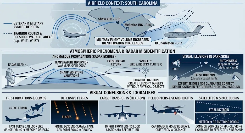
South Carolina’s military flying is not confined to circles immediately above its bases. Aircraft travel between airfields, military operations areas and offshore warning zones, sometimes in formations and at speeds or climb rates unfamiliar to people watching from the ground.
Shaw Air Force Base near Sumter and McEntire Joint National Guard Base near Eastover are particularly important to the state’s UFO geography because both operate F-16 fighters. Shaw’s own collision-avoidance guidance identifies the Gamecock and Bulldog military operations areas, together with offshore warning areas W-161 and W-177, as primary training areas used by aircraft from Shaw and McEntire. It notes that F-16s commonly depart in groups of two or more, climb at more than 6,000 feet per minute and may leave the area at roughly 350 knots. Seen from an uncertain angle, such a formation can appear to rise almost vertically, merge into one bright object or change direction abruptly.[Shaw Air Force Base]shaw.af.milShaw Air Force Base Crowded SkiesShaw Air Force BaseCrowded Skies - Shaw Air Force BaseApril 25, 2014 — 3 Feb 2014 — F-16s are normally on an IFR flight plan and climb ou…
A military operations area, or MOA, is airspace designated for activities such as formation work, intercept practice and abrupt manoeuvring. Civil aircraft are not automatically prohibited from every MOA, but military training within one may involve high speeds and rapid changes in altitude or direction. Warning areas off the coast serve a related purpose over international waters. This matters for coastal sightings because an object seen from Myrtle Beach, Charleston or the Lowcountry may be many miles offshore, making its distance, size and speed extremely difficult to judge.[faa.gov]sua.faa.govSpecial Use Airspace & Air Traffic Control AssignedAll SAA Air Traffic Control Assigned Airspaces, Alert Areas, Military Operations Areas, National Security Areas, Other Prohibited Area…
The traffic is diverse. Marine Corps Air Station Beaufort supports Marine aviation, including F-35B operations and training extending into airspace off South Carolina and neighbouring Atlantic coasts. Joint Base Charleston operates large transport aircraft, while McEntire supports both Air and Army National Guard aviation. Helicopters, tankers, transports and fighters therefore share parts of the state’s wider aviation environment rather than producing one easily recognised pattern of movement.[beaufort.marines.mil]beaufort.marines.milMCA S BeaufortMarine Corps WebsiteThe mission of Marine Corps Air Station Beaufort is to continue supporting establishment operations for 2nd Marine Ai…
Night activity adds another layer. Shaw has described exercises using expanded airspace during early-morning hours, when commercial traffic is lighter. Marine Corps planning documents also account for night flying at Beaufort. Such activity may be announced to aviation authorities without becoming familiar to the wider public, so residents can encounter unusually intense or unfamiliar flying without knowing that an exercise is under way.[af.mil]shaw.af.milShaw Air Force Base20th FW employs SCEWR in new, dynamic airspace exerciseShaw Air Force Base20th FW employs SCEWR in new, dynamic airspace exercise
This pattern complicates the interpretation of sighting clusters. Several reports from the same county or evening may indicate that many witnesses observed a real external stimulus, but they do not by themselves show that the stimulus was exotic. A formation exercise, repeated circuit flying or aircraft travelling towards a training area can generate multiple accounts from different towns, each describing apparently different movement because the viewing angles differ.
Why trained witnesses still matter
Military personnel, pilots, radar operators and experienced amateur astronomers are usually better placed than casual observers to recognise ordinary aircraft. Their reports deserve careful attention, especially when they include instrument readings, aviation terminology or comparisons with familiar traffic. South Carolina’s 1952 Congaree radar case remains important partly because the operators were trained and the Air Force regarded them as reliable.
Training, however, does not eliminate ambiguity. It improves the quality of a report; it does not guarantee that the witness had enough information to identify the cause. A fighter pilot may be highly skilled at judging another aircraft at known range while still being unable to estimate the size or distance of a solitary light against a dark, featureless background. NASA’s independent UAP study stressed that the central problem is usually the scarcity of calibrated, high-quality data rather than a lack of sincere testimony.[NASA Science]science.nasa.govScience Independent Study Team ReportScience Independent Study Team Report
Night vision is especially vulnerable. The Federal Aviation Administration warns about autokinesis, in which a stationary light appears to drift when watched against darkness without fixed reference points. It also describes false horizons created by cloud banks, coastlines, stars or patterns of ground lighting. Over South Carolina’s dark rural areas, wetlands and Atlantic coastline, such effects can make an ordinary light seem to hover, dart or climb. These illusions affect pilots as well as people on the ground; recognising them is part of aviation safety training precisely because expertise does not make the visual system immune.[Federal Aviation Administration]faa.gov12 afh ch1112 afh ch11
Perspective can also turn normal aircraft behaviour into an apparently impossible manoeuvre. An aircraft approaching almost directly towards an observer may seem motionless because its angular position changes very little. When it banks, its landing or formation lights can disappear suddenly, creating the impression that it accelerated away or switched off instantaneously. Two aircraft aligned along the same line of sight may appear as one object that later “splits”, while a turning formation can seem to rotate without changing shape.
Radar evidence requires similar caution. Radar can supply range and speed information that the unaided eye cannot, but it can also register birds, aircraft, atmospheric refraction, interference and ground or sea clutter. The National Weather Service uses the term anomalous propagation for false or displaced echoes caused when atmospheric layers bend radar energy in unexpected ways. Temperature inversions and sharp moisture changes are especially capable of producing such effects, sometimes creating returns where no airborne object is present.[National Weather Service]weather.govOpen source on weather.gov.
This is directly relevant to the Congaree case. The apparently extraordinary radar speed reported in December 1952 should not be treated as a clean measurement of a physical craft merely because experienced operators saw it. The absence of a simultaneous visual observation, together with the known possibility of radar interference and propagation effects, leaves a genuine investigative question rather than evidence of confirmed extreme performance. In military UFO history, “trained witness” should therefore raise the priority of a case, not close the argument.
Aircraft, flares, satellites and other lookalikes
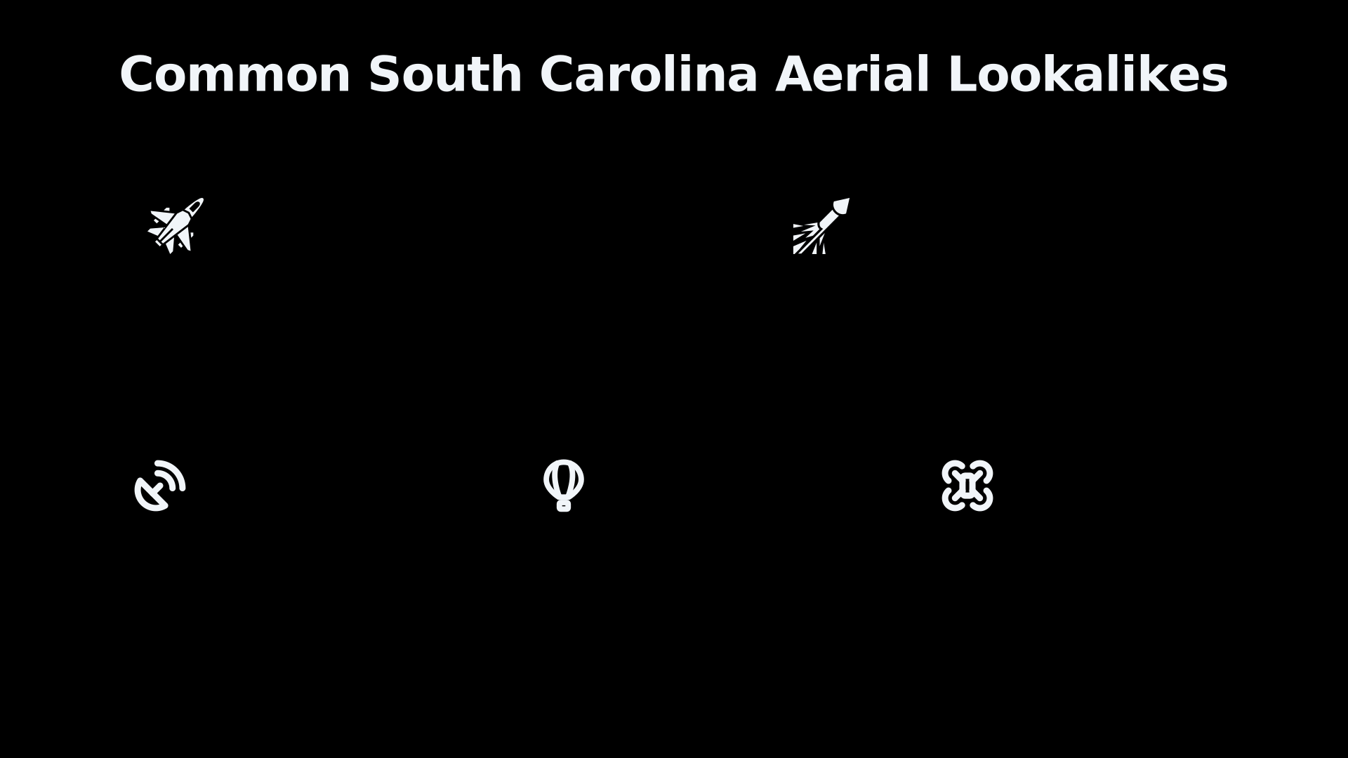
The most useful way to assess a South Carolina report is to ask which ordinary mechanism best matches its appearance, movement, duration and setting. Some explanations recur more often than others.
Fighters and aircraft formations. F-16s from Shaw and McEntire can climb rapidly, fly in pairs or larger groups and turn towards inland or offshore training zones. At night, their navigation, anti-collision and landing lights may dominate while the aircraft body remains invisible. A group viewed from ahead can resemble a stationary triangle or cluster; after the formation turns, the lights may spread apart or vanish in sequence. Shaw’s published material also confirms that local F-16 training includes the deployment of flares, demonstrating that both fast aircraft and bright decoys are present in the state’s skies.[Shaw Air Force Base]shaw.af.milShaw Air Force Base Crowded SkiesShaw Air Force BaseCrowded Skies - Shaw Air Force BaseApril 25, 2014 — 3 Feb 2014 — F-16s are normally on an IFR flight plan and climb ou…
Defensive flares. Military aircraft release hot countermeasure flares to distract heat-seeking weapons during suitable training. From a distance, these can appear as brilliant orange or white lights that ignite abruptly, descend slowly and fade. Several flares released along a flight path may form a row, arc or apparently motionless group. Wind can separate them, while perspective may make their downward movement hard to see. A flare explanation becomes stronger when lights appear successively, drift downward and extinguish within seconds or minutes. It becomes weaker if a clearly defined object remains visible after the lights fade or if reliable data show sustained powered movement.
Large transports and tankers. Aircraft associated with Joint Base Charleston may look surprisingly slow when seen at altitude, particularly when approaching head-on. Their bright forward-facing lights can be visible long before the shape of the aircraft is apparent. Because a large aircraft may remain on a nearly constant bearing for several minutes, witnesses can describe it as hovering before it turns and exposes its navigation lights or engine sound.
Helicopters. Military and emergency helicopters can hover, circle and operate at low altitude, sometimes with powerful searchlights. Sound direction can be misleading in wind or around buildings, and at sufficient range a helicopter may appear silent. A hovering light that later moves sideways is therefore not automatically unusual, especially near McEntire, military training land or emergency-response activity.
Satellites and Starlink trains. Satellites are now among the most common sources of unfamiliar lights. Newly deployed Starlink spacecraft may cross the sky as a line of evenly spaced points, while older satellites can brighten suddenly when sunlight reflects from their surfaces. Research reconstructing pilot reports has shown that Starlink reflections can produce apparently manoeuvring or clustered lights even for experienced flight crews. The apparent motion results from viewing geometry and illumination rather than propulsion.[arXiv]arxiv.orgOpen source on arxiv.org.
Drones. Consumer and commercial drones can hover, change direction sharply and display coloured or flashing lights. Distance is hard to judge, so a small nearby drone may be interpreted as a large object farther away. Military or public-safety drones add another complication because their operations may not be obvious to bystanders. The FAA’s controlled-airspace rules and facility maps show that drone activity around airports is regulated, but regulation does not mean that every observer will know when an authorised operation is taking place.[Federal Aviation Administration]faa.govuas facility mapsuas facility maps
Balloons and windborne objects. Weather balloons, party balloons and reflective foil balloons may appear stationary, move against the apparent wind at ground level or flash brightly as they rotate. Their motion can look erratic because winds differ sharply with altitude. The Pentagon’s All-domain Anomaly Resolution Office lists balloons, airborne debris, birds, conventional aircraft, drones and satellites among frequent sources of UAP reports.[AARO]aaro.milOpen source on aaro.mil.
Birds, insects and biological radar targets. Birds can reflect city or industrial lighting, particularly when flying in formation. On radar, birds and insects may create genuine moving returns even though no aircraft is present. Weather services have long used the term “angels” for echoes caused by birds, insects or small-scale atmospheric variations. This keeps the bird explanation relevant to South Carolina’s older cases, including the brief diamond formation reported by amateur astronomers near Greenville in 1952.[National Weather Service]weather.govOpen source on weather.gov.
Meteors and re-entering debris. A bright meteor may fragment, change colour and cross a large portion of the sky in seconds. Because witnesses often underestimate its height, they may believe it passed just above nearby trees or buildings. Space debris can last longer and break into multiple glowing pieces travelling along the same path. These explanations fit fast, one-directional events better than objects reported to stop, reverse or remain present for many minutes.
What makes a military-area report persuasive?
A sighting close to military airspace becomes more useful when the report contains information that can be checked. “A bright object near Shaw” is weak evidence because it supplies neither a reliable position nor a way to separate fighters from planets, satellites or drones. A report giving an exact time, compass direction, elevation, duration and sequence of movement can be compared with flight records, astronomical data, weather conditions and exercise notices.
The most valuable features are:
- an exact date and time, rather than “late at night”;
- the observer’s precise location and viewing direction;
- whether the object crossed stars, clouds or the Moon;
- changes in angular size, brightness and spacing;
- sound and any delay between sight and sound;
- original photographs or video with metadata;
- simultaneous observations from separated locations;
- radar, air-traffic-control or other sensor confirmation;
- evidence that known aircraft, satellites, balloons and exercises were checked.
Military transponders and public flight-tracking services can help, but their absence is not decisive. Some military flights are not displayed fully on public websites, and incomplete tracking data should not be turned into proof that no aircraft was present. Likewise, a base’s inability to confirm an activity does not necessarily establish that none occurred across neighbouring controlled, restricted or offshore airspace.
AARO and NASA both emphasise the importance of multiple, calibrated sensors. Images alone often lack range, while radar alone may lack a reliable identification. Combining radar, optical imagery, infrared data and observations from more than one position makes it possible to distinguish true movement from camera shake, parallax or atmospheric effects.[NASA Science]science.nasa.govScience Independent Study Team ReportScience Independent Study Team Report
This standard does not make unresolved cases meaningless. It separates three different outcomes that are often blurred together. A debunked report has a well-supported conventional explanation. A weakly unresolved report lacks enough information to decide among ordinary possibilities. A genuinely anomalous case retains measured features that remain difficult to explain after plausible alternatives have been tested. Most public South Carolina reports near military areas fall into the middle category rather than the third.
Why military skies both clarify and confuse
South Carolina’s bases make the state a valuable place to study unusual aerial reports because they bring trained observers, radar systems and strong aviation-safety incentives. An unexplained object near a fighter route or restricted area cannot responsibly be dismissed without checking whether it posed a hazard, represented an unauthorised drone or reflected unfamiliar foreign technology.
At the same time, military activity sharply raises the probability of misidentification. Aircraft may fly at night, in formation, at high speed or beyond the coverage visible on public tracking sites. Flares can imitate hovering lights; satellites can imitate formations; darkness can create apparent movement; and atmospheric conditions can corrupt radar. Secrecy surrounding some operations may also prevent a rapid public explanation even when officials understand the likely cause.
The balanced conclusion is therefore narrower than either extreme. South Carolina’s military connections do not prove that its UFO reports concern secret or non-human craft, but neither do common explanations justify dismissing every witness. The location tells investigators where to begin: with airspace charts, base activity, flight geometry, radar limitations and known lookalikes. Only after those possibilities have been tested does “unidentified” become an interesting result rather than simply the starting description.
Amazon book picks
Further Reading
Books and field guides related to How Military Flying Complicates South Carolina UFO Cases. Use these as the next step if you want deeper reading beyond the article.
UFOs: Generals, Pilots, and Government Officials Go on the Re...
Military aviation and official testimony are central themes.
eBay marketplace picks
Marketplace Samples
Live-tested eBay searches with available results related to this page.
Selected fromaviation poster oneBay.co.uk.



Endnotes
1.
Source: faa.gov
Title: Federal Aviation Administration Section 4
Link:https://www.faa.gov/air_traffic/publications/atpubs/aim_html/chap3_section_4.html
Source snippet
Special Use AirspaceSUA areas are depicted on aeronautical charts, except for controlled firing areas (CFA), temporary military operation...
2.
Source: sua.faa.gov
Title: Special Use Airspace & Air Traffic Control Assigned
Link:https://sua.faa.gov/
Source snippet
All SAA Air Traffic Control Assigned Airspaces, Alert Areas, Military Operations Areas, National Security Areas, Other Prohibited Area...
3.
Source: faa.gov
Link:https://www.faa.gov/air_traffic/publications/atpubs/aip_html/part2_enr_section_5.1.html
Source snippet
Federal Aviation AdministrationENR 5.1: Prohibited, Restricted, and Other AreasSUA areas are depicted on aeronautical charts, except for...
4.
Source: beaufort.marines.mil
Title: MCA S Beaufort
Link:https://www.beaufort.marines.mil/
Source snippet
Marine Corps WebsiteThe mission of Marine Corps Air Station Beaufort is to continue supporting establishment operations for 2nd Marine Ai...
5.
Source: beaufort.marines.mil
Link:https://www.beaufort.marines.mil/Portals/53/Docs/Volume_I_Final_EIS.pdf
Source snippet
f the coasts of North and South Carolina, Georgia, and Florida...
6.
Source: beaufort.marines.mil
Link:https://www.beaufort.marines.mil/Portals/53/Airfield%20Seizure%20Exercises_Finding%20of%20No%20Significant%20Impact%20and%20Final%20Environmental%20Assessment.pdf
7.
Source: beaufort.marines.mil
Title: 130912 MCAS Beaufort AICUZ Study
Link:https://www.beaufort.marines.mil/Portals/53/Docs/AICUZ/130912-MCAS-Beaufort-AICUZ-Study.pdf?ver=jrDHeSM63oidWcwCarAZJw%3D%3D
8.
Source: science.nasa.gov
Title: Science Independent Study Team Report
Link:https://science.nasa.gov/wp-content/uploads/2023/09/uap-independent-study-team-final-report.pdf
9.
Source: faa.gov
Title: 12 afh ch11
Link:https://www.faa.gov/sites/faa.gov/files/regulations_policies/handbooks_manuals/aviation/airplane_handbook/12_afh_ch11.pdf
10.
Source: faa.gov
Link:https://www.faa.gov/air_traffic/publications/atpubs/aim_html/chap8_section_1.html
11.
Source: faa.gov
Title: Spatial D
Link:https://www.faa.gov/pilots/safety/pilotsafetybrochures/SpatialD.pdf
12.
Source: weather.gov
Link:https://www.weather.gov/mlb/Doppler_Dual_Pol_Weather_Radar
13.
Source: weather.gov
Link:https://www.weather.gov/mkx/using-radar
14.
Source: forecast.weather.gov
Title: National Weather Service NOAA’s National Weather Service
Link:https://forecast.weather.gov/glossary.php?letter=a
15.
Source: arxiv.org
Link:https://arxiv.org/abs/2403.08155
16.
Source: arxiv.org
Title: arXiv Extreme Flaring of Starlink Satellites
Link:https://arxiv.org/abs/2405.13091
17.
Source: faa.gov
Title: uas facility maps
Link:https://www.faa.gov/uas/commercial_operators/uas_facility_maps
18.
Source: faa.gov
Link:https://www.faa.gov/documentLibrary/media/Advisory_Circular/Editorial_Update_AC_107-2A.pdf
19.
Source: aaro.mil
Link:https://www.aaro.mil/
20.
Source: weather.gov
Link:https://www.weather.gov/ggw/GlossaryA
21.
Source: weather.gov
Link:https://www.weather.gov/media/tbw/workouts/2022jan25_ww_radarSatellite.pdf
22.
Source: arxiv.org
Link:https://arxiv.org/abs/2305.18566
23.
Source: aaro.mil
Link:https://www.aaro.mil/UAP-Cases/Official-UAP-Imagery/
24.
Source: aaro.mil
Title: UAP Records
Link:https://www.aaro.mil/UAP-Records/
25.
Source: aaro.mil
Link:https://www.aaro.mil/FAQ/
26.
Source: aaro.mil
Link:https://www.aaro.mil/Submit-A-Report/
27.
Source: aaro.mil
Title: AARO Historical Record Report Vol 1 2024
Link:https://www.aaro.mil/Portals/136/PDFs/AARO_Historical_Record_Report_Vol_1_2024.pdf
28.
Source: faa.gov
Link:https://www.faa.gov/
29.
Source: faa.gov
Link:https://www.faa.gov/air_traffic/publications/atpubs/aip_html/chap3_section_4.html
30.
Source: faa.gov
Link:https://www.faa.gov/sites/faa.gov/files/about/office_org/headquarters_offices/avs/SD_UAV-EV1.pdf
31.
Source: faa.gov
Link:https://www.faa.gov/sites/faa.gov/files/Night_Ops_Ch13.pdf
32.
Source: faa.gov
Link:https://www.faa.gov/sites/faa.gov/files/data_research/research/med_humanfacs/oamtechreports/AM81-06.pdf
33.
Source: faa.gov
Link:https://www.faa.gov/sites/faa.gov/files/2022-01/NovDec2015.pdf
34.
Source: faa.gov
Title: FA A Safety Briefing
Link:https://www.faa.gov/sites/faa.gov/files/JanFeb2025.pdf
35.
Source: faa.gov
Title: AM82 06
Link:https://www.faa.gov/sites/faa.gov/files/data_research/research/med_humanfacs/oamtechreports/AM82-06.pdf
36.
Source: smd-cms.nasa.gov
Title: 2020 2024 nasa science plan yr 23 update final
Link:https://smd-cms.nasa.gov/wp-content/uploads/2023/09/2020-2024-nasa-science-plan-yr-23-update-final.pdf
37.
Source: nasa.gov
Link:https://www.nasa.gov/wp-content/uploads/2017/12/2021_agency_foia_log_0.xlsx
38.
Source: nasa.gov
Title: 2023 agency foia log.xlsx
Link:https://www.nasa.gov/wp-content/uploads/2025/08/2023-agency-foia-log.xlsx?emrc=54069a
39.
Source: nasa.gov
Link:https://www.nasa.gov/wp-content/uploads/2025/08/2022-agency-foia-log.xlsx?emrc=93a4ff
40.
Source: science.nasa.gov
Title: science committee july 2022 meeting minutes final signed
Link:https://science.nasa.gov/wp-content/uploads/2024/04/science-committee-july-2022-meeting-minutes-final-signed.pdf
Published: july 2022
41.
Source: mls.jpl.nasa.gov
Link:https://mls.jpl.nasa.gov/publications/
42.
Source: weather.gov
Link:https://www.weather.gov/media/btv/research/Radar%20Artifacts%20and%20Associated%20Signatures.pdf
43.
Source: weather.gov
Link:https://www.weather.gov/roc/WindFarms
44.
Source: training.weather.gov
Title: Tang2020 MRMSQPEupdates
Link:https://training.weather.gov/wdtd/courses/MRMS/lessons/Hydro-products/hydro2-v12.2/presentation_content/external_files/Tang2020-MRMSQPEupdates.pdf
45.
Source: training.weather.gov
Title: rac25 interpretation
Link:https://training.weather.gov/wdtd/courses/rac/documentation/rac25-interpretation.pdf
46.
Source: training.weather.gov
Title: rac23 principles
Link:https://training.weather.gov/wdtd/courses/rac/documentation/rac23-principles.pdf
47.
Source: news.sky.com
Link:https://news.sky.com/story/ufo-files-latest-new-release-in-us-reveals-reports-of-unexplained-green-orbs-discs-and-fireballs-13543508
48.
Source: shaw.af.mil
Title: Shaw Air Force Base Crowded Skies
Link:https://www.shaw.af.mil/Portals/98/Docs/Safety/20FW%20MACA%20Pamphlet%20Feb%202014.pdf?ver=2016-05-04-144609-993
Source snippet
Shaw Air Force BaseCrowded Skies - Shaw Air Force BaseApril 25, 2014 — 3 Feb 2014 — F-16s are normally on an IFR flight plan and climb ou...
Published: April 25, 2014
49.
Source: shaw.af.mil
Title: Shaw Air Force Base20th FW employs SCEWR in new, dynamic airspace exercise
Link:https://www.shaw.af.mil/News/Article-Display/Article/3320175/shadows-in-the-night-20th-fw-employs-scewr-in-new-dynamic-airspace-exercise/
50.
Source: shaw.af.mil
Title: Shaw Air Force Base Photos
Link:https://www.shaw.af.mil/News/Photos/?igtag=Tigers
51.
Source: Wikipedia
Title: Federal Aviation Administration
Link:https://en.wikipedia.org/wiki/Federal_Aviation_Administration
52.
Source: shaw.af.mil
Title: mil Photos
Link:https://www.shaw.af.mil/News/Photos/?igpage=99&igsearch=f&igsort=Title
53.
Source: shaw.af.mil
Link:https://www.shaw.af.mil/Portals/98/Shaw%20ADAIR%20Draft_EA%20%28Oct%202023%29.pdf
54.
Source: facebook.com
Link:https://www.facebook.com/FAA/
55.
Source: airforce.com
Title: south carolina
Link:https://www.airforce.com/ways-to-serve/air-national-guard/south-carolina
56.
Source: youtube.com
Link:https://www.youtube.com/user/FAAnews
57.
Source: nuforc.org
Link:https://nuforc.org/sighting/?id=122564
Additional References
58.
Source: youtube.com
Link:https://www.youtube.com/watch?v=ajAKuFxx8ss
Source snippet
US Military Releases 4 Mysterious UFO Videos, Including 'Six-Pointed Star' Object...
59.
Source: scguard.ng.mil
Title: Annual Report FY2018
Link:https://www.scguard.ng.mil/Portals/45/Documents/annual%20reports/Annual-Report-FY2018.pdf?ver=2019-12-09-120701-687
Source snippet
Annual Report FY18 - South Carolina National Guard9 Dec 2019 — F-16 jets return to McEntire Joint National Guard Base after Hurricane Flo...
60.
Source: youtube.com
Title: Time-lapse video catches mysterious lights over Myrtle Beach
Link:https://www.youtube.com/watch?v=RY2kqK9Sh_k
Source snippet
F-16 vs UFO? Pentagon UFO Files Leak: F-16 Intercept Video & Decades Of Mystery Revealed | LIVE...
61.
Source: youtube.com
Title: Object seen streaking across the sky in Georgia and South Carolina
Link:https://www.youtube.com/watch?v=4d6mfq2zVV4
Source snippet
SC residents report mystery drone sightings amid national concern...
62.
Source: youtube.com
Title: SC residents report mystery drone sightings amid national concern
Link:https://www.youtube.com/watch?v=zC8c5jLUxSs
Source snippet
Time-lapse video catches mysterious lights over Myrtle Beach...
63.
Source: war.gov
Link:https://www.war.gov/ufo/?type=.aud
64.
Source: aui.edu
Link:https://aui.edu/aaro-releases-report-on-unidentified-anomalous-phenomena-uap/
65.
Source: 8pointedstar.com
Link:https://www.8pointedstar.com/2026/05/26/aaro-origin-story/
66.
Source: facebook.com
Link:https://www.facebook.com/WCBDNews2/posts/eight-apache-pilots-have-been-suspended-from-flying-as-a-result-of-an-investigat/1451753393653379/
67.
Source: instagram.com
Link:https://www.instagram.com/reel/DK9fVRcuCcZ/